Wednesday 31 December 2014

My new career 'posing' as a modeller

Holy crap... I've been in Newcastle almost a year now already!!... and a helluva good time it's been all in all.  But a year which has felt faster than Pine Island Glacier ( I know... what a sucky glaciologist reference to a fast flowing glacier), but as I am already officially into my second year of my PhD it gets you thinking about what has already been achieved and what milestones there are ahead... and what better time to reflect than a lazy afternoon on New Years Eve?

Back at my postgraduate induction to the conveyor belt that is the university system, a talk was given by a third year PhD student in engineering who spoke of the various moments where a big ?? comes into your thoughts of your PhD project.. why am I doing this?  Is it important?  Is there any point?  And surely enough, these questions are commonplace in my mind as I stare at a spreadsheet full of numbers or a Matlab script that is underlined in copious amounts of red squiggles that I don't fully comprehend just yet.
A great example of what a PhD is summed up by a few simple diagrams in blog post by Matt Might that I saw earlier this year here:  http://matt.might.net/articles/phd-school-in-pictures 

The blip that is PhD research.. Sourced from above link


A small blip in the mad world that is research.... but something which contributes at least a little way.. and for me that little piece of a contribution is enough to make me work at these next two years of my life and whatever is beyond it.

A large hurdle of my PhD so far has been learning to make my computer do the work and let me put my feet up (i,e. running numerical model simulations).  Albeit with a lot of help and the framework of a working model already existing, I have managed to make my PC tell me a series of numbers and make pretty(ish) graphs from numbers I put in and conditions I set... then I go and watch the Hobbit or some crap film in the cinema, leaving a note for no-one to turn off the PC in my absence (mostly me doing it accidentally) and return to find the computer to have given me a series of results... some good, others..less so.

Model Running... Don't Touch!  :)
Modelled (blue) vs measured (red) melt at individual stations... some irregularities at some stations due to averages from short periods of measurement, prone to error.  


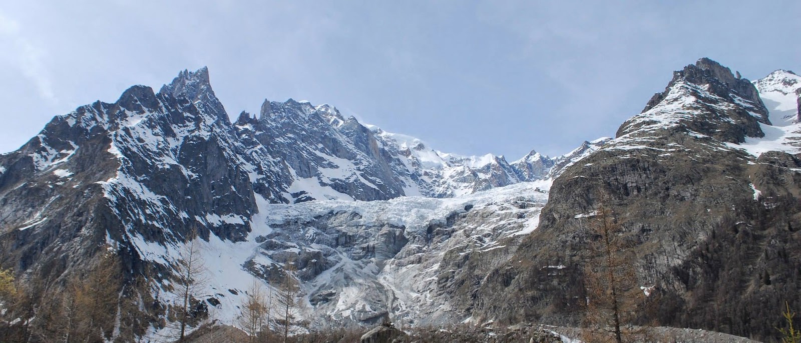
So here I am after nearly a year, with a great data set and a generally successful field season on the Miage Glacier in Italy (even considering the misfortune of Septembers field trip), some results to show, some lessons learnt, decent portions of time staring a screen with a blank expression and an almost complete energy balance melt model to run with different simulations of temperature distribution....   For where I am at the first year hurdle things are looking pretty darn good....

Every IS coming up Milhouse!


 ...still plenty of things to go wrong between now and a viva... but that's 2015's problem!


Just thought I'd share a few highlights from my year (despite Facebook's pressure to publish its auto-moments of 2014... and me agreeing to get it off my timeline)..

Happy New Year all

April fieldwork, lovely conditions and me making a first attempt at skiing :)


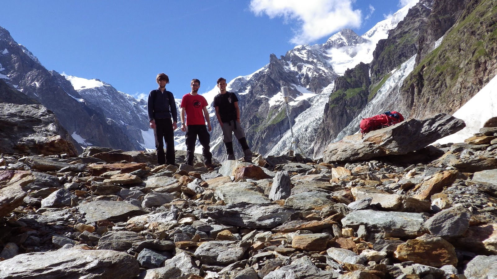
Being part of Mark's Grand Alpine Tour and doing some surveying of landslides...  some a tad risky in hindsight 
'Lovely' weather hikes in Svalbard 


And some funny ping-pong and cycling moments of course :)


Sunday 5 October 2014

Lessons from 'cursed' fieldwork


A pretty fantastic summer has come to end... though i'm a little late with reluctantly welcoming the autumn.  The summer months have been a wonderful mixture of Alpine adventure as part of the RGS Land Rover Grant and some PhD research at the foot of the impressive Mt Blanc Massif (and the associated sights that come with it).  After having just finished my fieldwork for the first year on the Miage debris-covered Glacier, it makes you reflective on what problems can occur during glaciological fieldwork, how important it can be and how annoyed it can make you.

Fieldwork last week consisted of 4 days of back-breaking transportation of tripods, weather stations and dataloggers over 10.5km squared of loose and slippery debris.  The following are the primary things that went wrong for us:

1. Stolen timelapse camera

To monitor the retreat of the snowline on the upper part of the glacier for running a distributed energy balance model, an expensive Harbortronics camera was mounted on the opposing valley and 'secured' to a large un-movable boulder (for me) sticking out from the ground.  As the camera was placed somewhere off-track and out of sight, the return to the site with a GPS in hand was almost necessary to get to the spot exactly after a 300-400m climb from the main route past the glacier.  To my surprise the boulder to which it was attached was smashed and the no trace of the camera was left.


- Important?
The data would have been useful and informative, though not crucial to my project... just an expensive camera

-Level of anger?
HULK SMASH (sad that nothing is safe, not even for research)


2. Flat tyre

A nice rental of a Skoda Superb (it was good... superb?? not sure) from Geneva airport gave us the space we needed to wedge all of our equipment in and return it to our storage location in Courmayeur.  Following a fantastic pizza from our usual favourite in the town, our journey back to the valley was met with an unfortunate hole in the road and a completely flat tyre.  Due to the inability to remove new car tyres without better tools and likely a health and safety concern, we were surprised to find a spare tyre hole with a lack of a tyre and just some puncture 'goo' not to dissimilar to what you put in your bike tyre to prevent punctures.... unsurprisingly it didn't work, though was designed as a 10 minute assistance anyway.

-Important?
The hassle to fix this was more of a cost to time (we lost our ride up the valley) and left us a man down for a while.

-Level of anger?
**it happens.  It was already 10pm when it happened, we just wanted to go to sleep... :)


3. Pro-glacial station somewhere in the Med.

Following 82mm+ rainfall during ~24th August (I wasn't there at this time) a major flood and the drainage of the ice-contact Lake Miage occurred (see below).  The destruction to the area beyond the main portal (exit) of water from the sub-glacial system was incredible, with new water routes carved into part of the glacier and much of the original river walls.  Unfortunately we were operating a pro-glacial station to measure changes in water depth and electro-conductivity of the material held in the melt water.  Again following our GPS led to an unhappy result.... our GPS informed us a further 5m forward would bring us to our location.... down a steep bank into the now-centre of the river.  Now these GPS units have a variable accuracy and would sometimes position us somewhere between the original pro-glacial station and Texas.. but it was clear to see that it wasn't here anymore.

The former image of the Miage Lake and two pictures of the drained lake and the crater remaining

Just a small part of the damage caused by the flood and the GPS with location of the station 5m ahead.


-Important?
The data again was supportive, though not crucial.

-Level of anger?
To be honest... the destructive power of nature was just impressive... it sucks to lose useful data and a good datalogger.... but its hard to argue with this one.


4. Waterproof temperature logger?

One important piece of data since mid-August that is potentially lost derives from a waterlogged temperature logger which was tightly sealed and considered waterproof.  One of the veteran stations from the April set-up had given up on me and became the only casualty of the main dataset this season.

-Important?
Yes!  Though the data for the rest of the stations is present and still comprises a unprecedented dataset of this nature over a debris-covered glacier to my knowledge.

-Level of anger?
I'm not angry... i'm just disappointed.


5. R.I.P. Camelbak

Following shifting a lot of heavy equipment in my backpack down the glacier, a quick lean against a rock to take the weight of my pack off me with taking it off and putting it back on in struggle resulted in a popped water pack :(

-Important?
Water is always important...

-Level of anger?
As fed up as anyone with a wet arse and no more drinking water


Ultimately, this felt like a slightly cursed trip to the Alps... but things could have been much worse.  Looking at the wider-picture, it becomes clear that bad things often happen with this type of fieldwork and projects may have to adjust to what is available.... I'm just glad that my hasn't changed too much.

Now on to the data-processing!

Sunday 6 July 2014

Invasion of the Celts

Holy Celtica!

  The valley below the tongue of Miage Glacier, home to me for the past two weeks is well populated by axe wielding, beard sporting, kilt wearing Celts!  It's a mixture of bizarre and amazing, with some great music and crazy dress codes.  My time on and off glacier has been supported by some bagpipes, violins and drums since Thursday... the fact that my tent has been boxed in by mobile homes and barking dogs is only mildly irritating considering I gain a free festival of music and character from the comfort of my wifi enabled hammock... sweet!  More on this here.


Some cool tree decorations... didn't get a shots of axe wielding Celts though.  


Resting my feet after a solid 2 weeks of glacier trekking feels good, though with plenty of data to organise already.  The main reason the feet have become destroyed from glacier trekking may have something to do with the relentless presence of debris on the surface and rapid change and retreat of it's ice cliffs, where ice exposed to the air at such a low altitude rapidly melts and shifts the pattern of rock and sediment.  The main annoyance is the movement between the upper an lower glacier.  My common description is like the beginning of the second Lord of the Rings installment where Frodo and Sam are attempting to get to Mordor but get lost scrambling around the similar appearance of jagged rocks.  Thankfully access to the upper glacier alone has a wonderful route around the western moraine ridge with a view over the Lago Combal + a lovely 200m climb to the glacier.


Happy to say now that since the beginning of July all my temperature stations and weather stations are in operation even though the 'amazing' GPS locates them somewhere between here and Argentina.  Following this, each station has been neighboured by a 2m PVC pipe from B&Q to act as a measure of melt under the different surface types and elevations up the glacier.  Manually drilling into the ice after digging up nearly 1m of debris at times really makes you appreciate the ability to attach an electric drill to the end of it (as was the case in Svalbard).  The fact that some anonymous undergraduates clearly blunted it through drilling in to debris didn't help progress... but replacing the blades of the drill then made me practically fly into the ice!  thank you Kovacs and your sharp drill heads, you saved me from a midnight ice drilling attempt...


Now I plan to enjoy a more relaxed stroll across the Miage over the next week to monitor my ablation stakes and download station data before I leave.  Accompanying me will be some scary Celts and some weather with mixed feelings.  Funnily enough, I get the strange looks for being geared up with ropes and ice axes, this bald, kilted guy needs to take a look at the blue paint on his face an return to his Celtic horn.

I leave you with a few time lapse images of clouds (used for science purposes... honest) over the lower weather station.


The camera was moved a bit for the last two.... not enough clouds :)

Thursday 19 June 2014

Glacier = 2 Swiss Francs

After just over a week out in the Land Rover, I can say I've seen some pretty amazing routes, and some things that I have wanted to see for some time (particularly in Austria).  The week's travel has taken me east along the Northern part of Italy, Aosta-Trieste, into Slovenia (amazing place! everyone must visit), into Austria, through Southern Germany, sneaking through Lichtenstein (for all of 20 minutes it takes to drive through) and into Switzerland, where I am currently held up in the Hotel Glacier du Rhone, at the foot of, you guessed it, the Rhone Glacier (RhoneGletscher).  The hotel itself is an impressive old building full of atmosphere, with a fabulous large book at the entrance showing off all the wonderful history of both the building and it's position with respect to the massively retreated glacier.

South-eastern Switzerland, the valley up to the small village of Juf

Ljubjlana, wonderful city

Bled-Slovenia, amazing colour of the water

                         The Pasterze Glacier, Austria... read a lot about this guy, good to see it at last

From some of the old images, photographs from the mid-late 1800's, you can see where the glacier tongue used to be, near the hotel, now not to be seen until you climb in the winding roads for a decent 10-15 minutes (faster in a Porsche).  I'm sure the original founder of such a grand (and creaky) building would be somewhat disappointed to find that the name for the hotel became less apparent after every morning view from his window saw a body of ice shying away.  If it was the service, the current glacier front would be making it's way back for sure... if it's the prices, then the current front of the ice should stay well up into the valley where it currently resides.  

A journey onto the glacier yesterday give me a wonderful feeling as glaciers usually do.  It reminds me how happy I am to be working in such a dynamic and interesting environment, that it shows so many small surface features that I even forget the names of... makes me a happy glaciologist.

                                       forgot the name of this fella

  My first experience of the Rhone yesterday has been both a pleasure and an annoyance.  For the first part, the glacier is wonderful example of the changes we can see in our environment, it's easy to access and it makes a nice walk, although with reasonable effort.  The annoyance derives from the fact that the only easy access and main access to the glacier is to pay 2 Swiss francs per person and walk through a tacky souvenir shop (and return before it closes?).  Essentially building a shop in front of the access point and charging you for it, unlike other locations where viewing towers etc are erected to give better views for those, who unlike me, don't want the harder climb.  This 2 Francs did include however the access the a sheltered ice cave near the current terminus (haven't been in yet).   This shelter is a tatty sheet of what was once a whitey tone, and now reflects the reduced albedo of the tongue, at least its not a circus tent of red and yellow stripes.  Im all for preserving the provision of freshwater from these glaciers, but it just feels like nature has been whored out for a couple of Francs... nothing new there I guess.

Rant aside, I'm looking forward to the next few days on the Rhone, conducting some surveys of the rock walls and trim lines using the UAV and the Structure from Motion techniques.  Hopefully to test some methods of vertical temperature profiles here too that can be compared to the debris surface of the Miage...fun fun fun :D

                                   ooooh, ablation stake :)


Monday 2 June 2014

should-be-manned aerial vehicle

The Grand Alpine Tour is now under way, with big Landy (still nameless as far as I know) leaving Newcastle in the early hours of today.  The main method of data capture for this epic adventure is the use of a UAV which is aiming to capture thousands of images and create 3D models of mountain and valley sides to assess the frequency and magnitude of landslides that occur above melting/retreating glaciers (see last week's post).

While the primary use of the big beast of a UAV is for another PhD project at Northumbria, it is hoped (and at least partly planned) that it will be made available for my own work on the Miage Glacier as well.  By strapping a TinyTag temperature logger and probes to the awesome 'little' flying machine it is hoped that I can log some data on vertical temperature profiles above the debris covered ice.  This is particularly interesting because the boundary layer meteorology above glaciers during the summer when they melt gives an idea of the 'free air' outside of the influence of the near surface.  By obtaining averaged temperature records for 1m intervals as high as we can manage (20m?) above the glacier, should give some interesting insights into the wider scale temperature controls on melt in such regions.

To say the methodology for this is nailed would be a lie.  Due to only having the larger S800 UAV (shown again below) for a short amount of time before going into the field with it, it is more of a try it and see approach.  (a youtube clip of this particular UAV with some music/camera action, in case you were interested?)


Looking back to March time, myself and Mark attempted this idea with the small DJI Phantom UAV.  One designed more for smaller projects, with less stability against the wind and one purchased largely for the purposes of practicing the idea of flying and capturing data.  Strapping the TinyTag logger onto the Phantom and the probes to each of it's little legs, we drove to Chester-le-Street (wanted to get out of the office anyway), paid for parking, and set the UAV onto the grass of a large park that I can't remember the name of.  Realising that we hadn't brought anything to detach the cabled-tied logger in case of problems, we thought we should just go for it.


This may have been one of the shortest science experiments in the world that doesn't involve rapid particle acceleration or the like.  Instantly after lifting off, the very lightweight logger unbalanced the UAV which did a 180 degree somersault landing upside down on its propellers and chipping one of them.  END.  Shame... it looked pretty bitchin'.

With a 10kg lifting weight, the larger UAV shouldn't have such a problem... but we will see how successful that will be :)

Science... gotta love it

Saturday 24 May 2014

Good News Everyone


Good news indeed... albeit a little delayed from the actual announcement... but this summer will be an awesome adventure of the Grand Alpine Tour, a research project and the recipient of this year's RGS (Royal Geographical Society) Land Rover grant.

 Principally organised by, and awarded to my PhD co-worker Mark Allan, the grant provides a team of people, including myself, the ability to conduct a significant fieldwork component of Mark's research project which is concerned with the frequency and magnitude of landslides which occur above melting/retreating glaciers in the European Alps.  The great interest in this project for me especially is the way in which the occurrence of these landslides impact the interaction of glaciers with the overlying atmosphere.  Because debris cover on glaciers acts to alter the response to climate, and much of the debris is often sourced from these landslide events, there is great importance attached to our need understand them.  Among several others, there will be some nice visits to the Rhonegletscher, Mer de Glace and my study glacier, the Miage.

Among other possible techniques, the main method for capturing this change is using the increasingly popular choice of a UAV (Unmanned Aerial Vehicle) or hexacopter if you will.  Constructing 3D models from mass amounts of images using structure from motion (SfM) imagery then allows this change to be realised.


  In addition to some generous funding, the grant provides the Grand Alpine Tour team with a shiny new kitted out Land Rover Defender to carry all the equipment and help us over the harder routes through the Alps.

The land rover.. looking pretty good in the pic below will be invaluable then to this project, which is represented in more detail on the webpage http://grandalpinetour.com/ ......and the Land Rover press release can be seen here


Throughout the duration of the trip, updates will be made to both twitter and facebook pages.   Give them a like/follow... interesting things to come! :)

Sunday 11 May 2014

I will be buried under a Mt Blanc Massif amount of data

Currently in a phase between the post-fieldwork blues of last month (still) and thoughts and enthusiasm for next months re-visit (now with 50% extra sun).  The time is mostly spent thinking about what can be done with the mountains of data I will have stored on my computer at the end of the melt season and what I want to achieve with it.

If each station has a sample of temperature every 10 minutes for both the air and the ground below it (some with humidity), for 3-5 months and there is a total of 15 stations, PLUS... a complete array of data from two automatic weather stations which record radiation from the sky and the ground, the wind speed and direction, humidity of the air, temperature and more... There are more units of data than I can even put the effort into counting.  On top of that there will be data from:

-A pro-glacial station recording discharge and possibly electro-conductivity (no dye tracing this year though),

-Ablation measurements from an ablation stake at each station location

 -My own body weight in photos if printed (hopefully some time lapse imagery too!)....

On the whole... the fun fieldwork component to this research project definitely is balanced by an equally non-fun organisation and processing of data.  The results and findings of such a rich and highly resolute dataset will most likely be very interesting.... but there are going to be some painstakingly long hours to come to that stage, which I am not looking forward to so much :) .

The main focus of my planning at the current time is using past years of data on the Miage Glacier (studied since 2005 by my supervisor) to understand the main forcing mechanisms upon temperature variations and most importantly using a slightly larger dataset from last year to predict temperatures across the glacier.

If we apply the knowledge of temperature lapse rates, that I rambled on about back in February then we can attempt to make estimates on what temperatures across the glacier should be.  Using data from two stations to predict temperature for a station between them (as shown by the red circle in the image below) would be similar to the typical approach adopted by many modelling studies (with various success)... and that is what I have done for some data from 2013.


As is described by a detailed meteorological study of the Miage between 2005-07 by Brock et al. (2010), the temperature variations are controlled less by the increase in the altitude than they are by the debris beneath them, which heats under the shortwave receipts from the sun and heats the above by convection.  Therefore assuming a certain temperature increase between two stations with lapse rates is not a million miles off.... but also not that accurate at peak daytime hours when the heating from below is strongest.


If the dashed line is our measured temperature at the middle station shown above, predictions using a constant change of temperature with elevation throughout the day from:

1) Environmental lapse rates (blueish line)
2) Average lapse rates for the Miage (purple line)
3) Lapse rates which change throughout the day (green line)

all fail to successfully replicate temperature at this middle station, particularly beyond midday because of heating of the ground debris.

Therefore the prediction of temperature over debris glaciers is likely to better when assessed from the variation in surface characteristics such as the thickness of the debris.

Short of digging up the entire debris surface from the glacier, we have to infer thickness from relationships with the surface temperature which can be observed at certain times of day with thermal imagery from satellites (technology eh?).  But this has its limitations and assumptions also.  Anyone interested should definitely read the paper by Foster et al. (2012) which is focused on this very issue for the Miage Glacier.

The importance being that debris on top of the ice is very important in controlling the interactions with the atmosphere and a glaciers response to climate.  This debris thickness is constantly evolving and it flows with the glacier down slope and is fed by the surrounding mountains (some interesting news on that next week!).  Therefore, the study of debris glaciers will likely become more globally apparent into the future.


References

Brock, B. W., Mihalcea, C., Kirkbride, M. P., Diolaiuti, G., Cutler, M. E. J., & Smiraglia, C. (2010). Meteorology and surface energy fluxes in the 2005–2007 ablation seasons at the Miage debris-covered glacier, Mont Blanc Massif, Italian Alps. Journal of Geophysical Research, 115(D9), D09106. doi:10.1029/2009JD013224

Foster, L. A., Brock, B. W., Cutler, M. E. J., & Diotri, F. (2012). Instruments and Methods A physically based method for estimating supraglacial debris thickness from thermal band remote-sensing data. Journal of Glaciology, 58(210), 677–691. doi:10.3189/2012JoG11J194


Monday 21 April 2014

Reflections on fieldwork and testing

It's amazing how, if you live in the city, no one casually says hello in the street or smiles without knowing you.

However, if you venture out into the countryside, you get casual greetings here, there and everywhere... particularly in England... but not only England.

This weekend, I got bored of Newcastle for the day and took the train out to Hadrian's Wall, a 73 mile long, 2/3 metre wide Roman construction designed for Emperor Hadrian's back garden because he didn't like his neighbours.


During my spontaneous trip I experienced variations in the amount of people passing the other direction, larger amounts of day trippers nearer the car parks and points of interest (the weather was good enough to give me sunburn).  I was interested to see that if there were more 5/6 people in quick succession passing by, the politeness disappears, and city life resumes.  This kind of makes sense when we consider how strange we would be to greet each passer by in such a way that quickly ('hi, heya, howdy-doo, great day eh? hey, good day, jolly good!).  I'm curious at what stage we resort to this pleasantry and when we decide there are too many people to be pleasing everyone?

The reason this springs to mind is that during the summer near (and on) the glacier, there will likely be a ****-ton of tourists.  Does this rule apply to the Italians and internationals in the valley? (most likely), do I need to explain to everyone the reason i'm walking around with radiation shields (radiation? RADIATION!?).  I'm aware it is a likelihood and it may very well be annoying.  Hopefully I can at least use some of the public services to good use that didn't exist in the April venture... such as a coach along the road which runs by the tongue of the glacier (snowmobile was more fun) and campsites in the valley... maybe I can even con some tourists with large backpacks to carry stuff for me?

The week in Italy was truly great and I managed, with the help of several people to get a total of 6 stations measuring air temperature installed at various locations on the glacier. More equipment was stashed at an upper station for ease of transportation in June, but while utilising its ability to log local temperature information until that time.  So at the upper most station where the tributaries of the other glaciers meet the Miage (see below), I established a measure of the near surface vertical temperature profile at 1, 1.5 and 2 metres over a quickly diminishing snow cover.  This will hopefully give a lovely transition between an unstable boundary layer (where surface temperature is lower than the overlying air) and a stable layer (which follows the more traditional decrease of temperature with increasing elevation).  However in June, this multiple height set up will be partly disassembled leaving the 2m measure and transporting the remaining sensors further up glacier.
This highest station was approximately 2400 metres above sea level (masl).  The highest station is set to be 2700masl.  higher than this, and the gradient increases too greatly and the inclines are characterised by risky ice falls which couldn't support stations anyway.  Higher up upon the glacier, the ice from the falls of the Mont Blanc and Dome glaciers crack and the rocks fall almost continuously (mostly in small pieces).  It reminds you how active and dangerous this region can be.  Most stations are situated in suitable and reasonably safe places, though one or two occupy areas which in 2012 was subject to a significant blowout of ice from the tributaries (picture from Fondazione Montagna Sicura).


So the stations will range from numbers 1-14 with two full weather stations and one off-glacier station (OG) designed to test the temperature changes independent of the potential cooling affect of glacier ice (even if buried under debris).


Currently it looks something like this, if I were to take a lovely aerial image from 2012 and put some inaccurate dots in paint (I'm too lazy for ArcMap today):


Though the GPSs have done a bit of a lousy job at positioning us where we should be (think my paint image is better).  This can be reasonably confirmed by ArcMap software (GIS) which shows that the coordinates given puts an off glacier station ON the glacier.  The limitation of satellite coverage in the afternoon in the upper parts of the glacier gives slightly more inaccurate readings anyway.

"anybody out there?"

I feel that after all the testing of sensors in the TomCave, the measures of temperature were reasonably accurate... but another test was conducted using all the sensors that were left in Italy from last year as well... and the results... not bad.. though a bit more messy.


The test ~700 metres from the tongue of the glacier was a good idea to test the other sensors, but also under conditions more accurate to that on the glacier, such as multiple reflections from high albedo surfaces such as snow and at similar elevations.  While one temperature sensor was giving a few too many large errors (several lines in the upper graph show comparison with it), the others were recording mostly reasonable differences in temperature and times where errors are higher can be understood better and can benefit analysis when looking at the final dataset.  The sensor with the largest error was also set up at TT10 (upper glacier) to give it a further test.

camping is booked for June.... can't wait... shame that for now, I have to stay in England with it's walls :)

Sunday 13 April 2014

Miage, April 2014

WOW!

Awesome week of fieldwork!  This time last week, I was just approaching the mountains after a dull AutoRoute drive through France for the previous 6 hours, not fully prepared for the wonderful sights of Courmayeur, Val Veny and the Miage Glacier.

The week was a clear contrast between long days of hard work and physical exhaustion (at least on my part) and more chilled days where we recovered our feet from 12hours or more of climbing, walking, standing and ,of course, skiing in rigid plastic boots and organised ourselves for further fieldwork.. all under the comfort of warm spring sunshine.


The first day was occupied with obtaining our rented skis which the gentlemen at the rental shop seemed to have trouble correctly sorting the bindings (I grew to hate the delicate precision of attaching my feet into those bindings!).  Secondly, we had to venture to the storage of more temperature loggers stored at the Fondazione Montanga Sicura above La Palud where our hotel was.  By the time we had lunch at 2pm, we thought we really should do some work... and with temperature loggers programmed by an incredibly slow notebook laptop, we drove ourselves to the Brenva Glacier road and attached our feet to some nice lightweight 600 euro skis.  With skins on our skis and with the snowsled in tow, we hauled the tripods, radiation shields and temperature loggers several kilometres to a suitable site to again test the temeprature readings under snow conditions (more on that next time) before beating the sunset back to the town.

The second day was dominated by a reasonable amount of rain and poor visibility as we had seen on the forecast, and therefore was a day we had set aside for other work and prepping for the rest of the week.  However, what we hadn't fully accounted for was the increased instability of the rock face above the small town of La Palud where we stayed, and the whole place had to be evacuated that morning.  Realising that equipment had to be stored at the Fondazione for summer, it was a slight race against time, in the opposite direction to traffic to store this equipment before the town was blocked to almost all access! It felt a little like a scene from a movie at one stage... Unfortunately, the siren didn't sound as they promised...that would have added to the Hollywood feel.

Wednesday was our first day onto the glacier, although with some effort.  We managed to elect the help of local restaurants and businesses in the valley who operated snowmobiles to transport food and equipment to ski lift areas in the valley en route to the glacier (Val Veny).  Then we collected the equipment from Monday's adventure and pulled the snow sled up some even greater inclines.  Some more locals helped with another old skidoo (snowmobile) which I jumped on eagerly and held onto the snowsled which raced behind us and almost ripped my arm from its socket.  Only until the route became much thinner and steep sided and the skidoo went over with me and the driver on it.  He spoke no English, and I, no Italian beyond the very basics... but we organised ourselves to lift the heavy skidoo, dig it out of the snow and turn it around.  After waiting for the rest of the party, we stashed the sled, took a tripod each and climbed the 200m moraine to get the first real glimpse of the full glacier!  After installing 3 stations on the lower glacier I undertook my first proper downhill skiing session through the forest at the tongue of the glacier... not the easiest experience and after several struggling attempts to mess with my bindings I was tired and ready for a pizza!  We got back to the Brenva road at 9pm, 12 hours after leaving.

The following day was the largest ascent, utilizing the local snowmobiles once more as far as possible, collecting the remaining equipment we stashed the previous day and getting onto the glacier from the far west side of the tongue past the Lac du Combal.  I realised quickly that I was the best at going uphill.... downhill, lets not talk about that so much.  With 3 more stations installed, the ski downglacier commenced.  The parts where I could stop myself were reasonably good fun I must admit, the steeper parts... less fun for me.  I donned my climbing helmet due to the covered debris which i would likely fall onto at some stage in my downhill venture.  But the whole experience was fantastic and great to witness some snow on the glacier before the melt fully encapsulates the surface and the full display of debris becomes apparent.

The final day was an organisation of the notes made, pictures taken and packing and cleaning the van before returning back to the UK + relaxing in the sun with a beer and messing with the time lapse equipment (non of this on the glacier just yet).

I will most definitely share a greater level of detail of the 'science' in a post soon, but for now:

PICTURES!


The massively retreated Brenva Glacier, visibly restricted to a fair sized ice fall, with the debris it initially deposited acting as a nice little obstacle to climb before entering the valley toward the Miage.


Snowsled pulling toward the calibration site on the first day (~4pm).

Calibration test at the bridge just before the small settlement of La Visaille. 


Snowmobile ride back to calibration site 2 days later.


As we stashed the sled (well hidden!).  


Just after the moraine climb on Wednesday, tricky to walk in ski boots, glacier view almost in sight.


The view toward the tongue of the glacier.  Patchy sow and thick debris underneath... interesting skiing.  


More station set up... clearly having fun.  


Next day, western moraine ascent, me up top.  


Toward the upper part of the glacier, heading for highest site we placed until June.  In the distance are the tributaries of the La Tete Caree, Bionassy, Dome and Mont Blanc Glaciers.  


Skiing down glacier :) 


Back to the lower glacier for a data download (we forgot the cable on the previous day), helmet for safety around 'radiation' shields.  


Would like to mention a great thanks to April's wonderful field assistants:

Ingeborg Pay (oh Deer)


Saskia Gindraux

 (Photo not representative of fieldwork Saskia, I just think it's funny :) )


Clare Webster

(At least en route to fieldwork)


And special thanks to:

Dr Philip Deline (Université de Savoie)
and
Dr Ben Brock (Northumbria University)